Cascapédia–Saint-Jules
Cascapédia–Saint-Jules | |
|---|---|
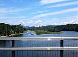
 Cascapedia River seen from Route 132 in Cascapédia–Saint-Jules in July 2018 | |
 Location within Bonaventure RCM | |
| Coordinates: 48°15′N 65°55′W / 48.250°N 65.917°W[1] | |
| Country | Canada |
| Province | Quebec |
| Region | Gaspésie– Îles-de-la-Madeleine |
| RCM | Bonaventure |
| Constituted | June 2, 1999 |
| Government | |
| • Mayor | Ashley Milligan |
| • Federal riding | Gaspésie— Îles-de-la-Madeleine |
| • Prov. riding | Bonaventure |
| Area | |
• Total | 163.03 km2 (62.95 sq mi) |
| • Land | 164.29 km2 (63.43 sq mi) |
| There is an apparent contradiction between two authoritative sources. | |
| Population (2021)[3] | |
• Total | 764 |
| • Density | 4.7/km2 (12/sq mi) |
| • Pop (2016-21) | |
| • Dwellings | 385 |
| Time zone | UTC−5 (EST) |
| • Summer (DST) | UTC−4 (EDT) |
| Postal code(s) | |
| Area code(s) | 418 and 581 |
| Highways | |
| Website | cascapediastjules |
Cascapédia–Saint-Jules is a municipality in Quebec, Canada.
The municipality includes the communities of Grande-Cascapédia and Saint-Jules, both located along the Cascapédia River.
History
[edit]On June 2, 1999, the Municipalities of Grande-Cascapédia and Saint-Jules were merged to form the Municipality of Cascapédia. It was renamed to Cascapédia–Saint-Jules on June 26, 2000.[1]
Grande-Cascapédia
[edit]Kigicapigiak had been a Mi'kmaq summer coastal community prior to European settlement.[4][5] Grande-Cascapédia was formed in the mid 19th century. Named after the adjacent river, originally called Cascapédiac, this name is from the Mi'kmaq words kaska (broad) and pegiag (river). In 1860, the local parish was established that 3 years later counted some 1500 inhabitants, and in 1883, its post office opened. In 1929, the place was incorporated as a municipality.[6] Another theory on the etymology is that it was named for the Mi'kmaq word kěskebeâk which means "wide paddle."[7]
Saint-Jules
[edit]Saint-Jules was founded as a mission in 1899, and became a parish only 2 years later. It was named after Pope Julius I, and also called Saint-Jules-de-Maria (1922-1950) or Saint-Jules-de-Cascapédia to distinguish it from Saint-Jules in the Beauce region. Its post office opened in 1922. In 1949, the place was incorporated as a separate municipality out of the Township Municipality of Maria.[8]
Demographics
[edit]Population
[edit]| 2021 | 2016 | 2011 | |
|---|---|---|---|
| Population | 764 (+4.7% from 2016) | 730 (-1.5% from 2011) | 741 (+3.8% from 2006) |
| Land area | 164.29 km2 (63.43 sq mi) | 163.45 km2 (63.11 sq mi) | 162.61 km2 (62.78 sq mi) |
| Population density | 4.7/km2 (12/sq mi) | 4.5/km2 (12/sq mi) | 4.6/km2 (12/sq mi) |
| Median age | 46.8 (M: 45.2, F: 48.4) | 47.6 (M: 46.2, F: 48.5) | 46.5 (M: 46.9, F: 45.7) |
| Private dwellings | 385 (total) 347 (occupied) | 355 (total) | 403 (total) |
| Median household income | $64,000 | $54,784 | $43,530 |
| Year | Pop. | ±% |
|---|---|---|
| 2001 | 679 | — |
| 2006 | 714 | +5.2% |
| 2011 | 741 | +3.8% |
| 2016 | 730 | −1.5% |
| 2021 | 764 | +4.7% |
| Source: Statistics Canada[14] | ||
Language
[edit]Mother tongue (2021):[3]
- English only: 52.9%
- French only: 43.1%
- English and French: 3.3%
- Other language: 0.7%
See also
[edit]References
[edit]- ^ a b "Cascapédia–Saint-Jules (Municipalité)" (in French). Commission de toponymie du Québec. Retrieved 2011-12-30.
- ^ a b "Répertoire des municipalités: Geographic code 05077". www.mamh.gouv.qc.ca (in French). Ministère des Affaires municipales et de l'Habitation. Retrieved 2024-09-19.
- ^ a b c "Cascapédia–Saint-Jules (Code 2405077) Census Profile". 2021 census. Government of Canada - Statistics Canada. Retrieved 2024-09-19.
- ^ "Micmac Locations". Micmac Tribe. Access Genealogy. Retrieved 27 May 2014.
- ^ Vetromile, Eugene (1866). The Abnakis and their history. J.B. Kirker. p. 59.
- ^ "Grande-Cascapédia" (in French). Commission de toponymie du Québec. Retrieved 2011-12-30.
- ^ Rand, Silas Tertius (1875-01-01). A First Reading Book in the Micmac Language: Comprising the Micmac Numerals, and the Names of the Different Kinds of Beasts, Birds, Fishes, Trees, &c. of the Maritime Provinces of Canada. Also, Some of the Indian Names of Places, and Many Familiar Words and Phrases, Translated Literally Into English. Nova Scotia Printing Company.
- ^ "Saint-Jules" (in French). Commission de toponymie du Québec. Retrieved 2011-12-30.
- ^ "2021 Community Profiles". 2021 Canadian census. Statistics Canada. February 4, 2022. Retrieved 2023-10-19.
- ^ "2016 Community Profiles". 2016 Canadian census. Statistics Canada. August 12, 2021. Retrieved 2024-09-01.
- ^ "2011 Community Profiles". 2011 Canadian census. Statistics Canada. March 21, 2019. Retrieved 2014-02-03.
- ^ "2006 Community Profiles". 2006 Canadian census. Statistics Canada. August 20, 2019.
- ^ "2001 Community Profiles". 2001 Canadian census. Statistics Canada. July 18, 2021.
- ^ 2001, 2006, 2011, 2016, 2021 census

