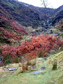
Brontë Waterfall
| Brontë Waterfall | |
|---|---|
 | |
 | |
| Location | West Yorkshire, England |
| Coordinates | 53°49′6.05″N 2°0′12.95″W / 53.8183472°N 2.0035972°W |
Brontë Waterfall on the South Dean Beck is about a mile south-west of Stanbury, near Haworth in West Yorkshire, England. The area surrounding the waterfall is mainly moorland and farmland in Brontë Country, an area of outstanding beauty famous for its association with the Brontë sisters.[1] Below the falls is Brontë Bridge, an old stone bridge across the beck.[2] A flash flood in May 1989, swept the bridge away. In March 1990, a Lynx helicopter from No. 9 Regiment Army Air Corps, airlifted five gritstone slabs into the narrow valley to allow park rangers to repair the crossing.[3]
Brontë trail
[edit]The Brontë Trail, a nature trail, starts in Haworth in the South Pennines and crosses the moors to the waterfall. Continuing on, Top Withens can be reached on the same walk. The location of the ruined farmhouse is reputed to have been the inspiration for the setting of Wuthering Heights, the 1847 Emily Brontë novel.[4]
See also
[edit]References
[edit]- ^ "Top Withens (aka Wuthering Heights)". BBC Home. BBC. 24 September 2014. Retrieved 29 March 2016.
- ^ "Bronte country, The Pennines, Yorkshire". The Guardian. 20 May 2006. Retrieved 29 March 2016.
- ^ Davenport, Peter (29 March 1990). "Air skill restores Brontë Bridge". The Times. No. 63666. p. 5. ISSN 0140-0460.
- ^ "Top Withens - the inspiration for the Wuthering Heights farmhouse?". wuthering-heights.co.uk. Retrieved 12 July 2021.
External links
[edit]- Website for Haworth relating to the Brontë waterfall walk
- Web news magazine of the Brontë Parsonage Museum

