Bromarv
Bromarv
Bromarv – Bromarv Bromarf | |
|---|---|
Village (former municipality) | |
| Bromarv kommun Bromarvin kunta | |
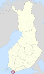
 Location of Bromarv in Finland | |
| Coordinates: 59°59′30″N 23°02′00″E / 59.99167°N 23.03333°E | |
| Country | Finland |
| Region | Uusimaa |
| Founded | before 1300 |
| Consolidated | 1865 |
| Area | |
• Total | 197.00 km2 (76.06 sq mi) |
| Population (1973);[1] | |
• Total | 1,574 |
| • Density | 8.0/km2 (21/sq mi) |
| Time zone | UTC+2 (EET) |
| • Summer (DST) | UTC+3 (EEST) |
| Postal code | 10570 |
| Climate | Dfb |
| Website | http://www.bromarv.fi |
Bromarv (Finland Swedish: [ˈbroːmɑrv, ˈbruː-];[2] Finnish: Bromarv) is a village and former municipality of Finland comprising the former municipalities Tenala together with the town of Ekenäs. It was merged with Pohja and Karis to form the new municipality of Raseborg on January 1, 2009.

Bromarv was located in the province of Southern Finland and was part of the Uusimaa region. The port town of Hanko is located 15 kilometres (9.3 mi) south of Bromarv.
The town was bilingual, with the majority being Swedish speakers (91,7%).
It is noted for its archipelago, part of which is the Raseborgs västra skärgård.
The municipality is home to the historical Riilahti Manor and the Battle of Gangut War Memorials.[3]
Sub-region of Uusimaa
[edit]Bromarv was also the name of a sub-region of Uusimaa, also known as Nyland.
-
Midsummer pole in 2019 in Bromarv harbour.
-
Bromarv parish granary built in 1878.
-
The new church, built in 1981 after the old one was burnt down.
References
[edit]- ^ a b http://www.toti.eu.com/nordic.municipalities/kunta.asp?id=24 Bromarv information (in Finnish)
- ^ "Bromarv, Bromarv - Finlandssvenska bebyggelsenamn".
- ^ Wolff, Charlotta; Nurmiainen, Jouko (2022). Johan Fredrik Aminoff: kustaviaani kahdessa valtakunnassa. Otava, kustannusosakeyhtiö. Helsingissä: Kustannusosakeyhtiö Otava. ISBN 978-951-1-46554-6.
External links
[edit]![]() Media related to Bromarv at Wikimedia Commons
Media related to Bromarv at Wikimedia Commons


