Bregenz District
Appearance
(Redirected from Bregenz (district))
Bregenz District
Bezirk Bregenz | |
|---|---|
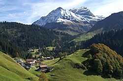
 View of Schröcken | |
 | |
| Country | Austria |
| State | Vorarlberg |
| Number of municipalities | 40 |
| Area | |
| • Total | 863.37 km2 (333.35 sq mi) |
| Population (2012[1]) | |
| • Total | 130,425 |
| • Density | 150/km2 (390/sq mi) |
| Time zone | UTC+01:00 (CET) |
| • Summer (DST) | UTC+02:00 (CEST) |
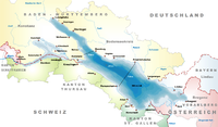
The Bezirk Bregenz is an administrative district (Bezirk) in Vorarlberg, Austria. It comprises the Bregenz Forest region, the Leiblach valley, and the Austrian part of Lake Constance.
The area of the district is 863.37 km2, its population is 130,425 (2012), and the population density is 151 people per km2. The administrative centre of the district is Bregenz.
| Year | Pop. | ±% |
|---|---|---|
| 1869 | 41,186 | — |
| 1880 | 41,628 | +1.1% |
| 1890 | 44,864 | +7.8% |
| 1900 | 49,479 | +10.3% |
| 1910 | 53,785 | +8.7% |
| 1923 | 51,644 | −4.0% |
| 1934 | 56,304 | +9.0% |
| 1939 | 56,407 | +0.2% |
| 1951 | 70,056 | +24.2% |
| 1961 | 78,958 | +12.7% |
| 1971 | 95,235 | +20.6% |
| 1981 | 105,345 | +10.6% |
| 1991 | 115,500 | +9.6% |
| 2001 | 121,123 | +4.9% |
| Source: Statistik Austria | ||
Administrative divisions
[edit]The district is divided into 40 municipalities, one of them is a town, and six are market towns.
Towns
[edit]- Bregenz (28,012)
Market towns
[edit]Municipalities
[edit]- Alberschwende (3,139)
- Andelsbuch (2,356)
- Au (1,684)
- Bildstein (714)
- Bizau (1,015)
- Buch (556)
- Damüls (324)
- Doren (1,024)
- Eichenberg (379)
- Fußach (3,726)
- Gaißau (1,700)
- Hittisau (1,852)
- Höchst (7,764)
- Hohenweiler (1,261)
- Kennelbach (1,860)
- Krumbach (2,252)
- Langen (1,300)
- Langenegg (1,066)
- Lingenau (1,341)
- Lochau (5,490)
- Mellau (1,311)
- Mittelberg (5,013)
- Möggers (517)
- Reuthe (611)
- Riefensberg (1,024)
- Schnepfau (472)
- Schoppernau (934)
- Schröcken (228)
- Schwarzach (3,746)
- Schwarzenberg (1,822)
- Sibratsgfäll (395)
- Sulzberg (1,760)
- Warth (1,521)
(population numbers 2012)
Notes and references
[edit]- ^ "vorarlberg.at Landesstatistik Bevölkerung". Land Vorarlberg. Archived from the original on 2008-06-17. Retrieved 2008-08-04.


