Trotuș
| Trotuș Tatros | |
|---|---|
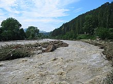
 The river Trotuș in Târgu Trotuș, Bacău County | |
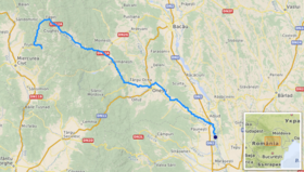
 Path of the river Trotuș [1] | |
| Location | |
| Country | Romania |
| Counties | Harghita, Bacău, Vrancea |
| Towns | Comănești, Onești, Adjud |
| Physical characteristics | |
| Source | Ciuc Mountains |
| Mouth | Siret |
• location | Adjud |
• coordinates | 46°00′40″N 27°12′33″E / 46.01111°N 27.20917°E |
| Length | 162 km (101 mi) |
| Basin size | 4,456 km2 (1,720 sq mi) |
| Basin features | |
| Progression | Siret→ Danube→ Black Sea |
| Tributaries | |
| • left | Asău, Tazlău |
| • right | Uz |

The Trotuș (Hungarian: Tatros) is a river in eastern Romania, a right tributary of the river Siret.[1][2][3] It emerges from the Ciuc Mountains in the Eastern Carpathians and joins the Siret in Domnești-Sat near Adjud after passing through Comănești and Onești in Bacău County.[4] The total length of the Trotuș from its source to its confluence with the Siret is 162 km (101 mi).[2][5] Its basin area is 4,456 km2 (1,720 sq mi).[2][5][6]
Towns and villages
[edit]The following towns and villages are situated along the river Trotuș, from source to mouth: Lunca de Sus, Lunca de Jos, Ghimeș-Făget, Palanca, Agăș, Comănești, Dărmănești, Târgu Ocna, Onești and Adjud.
Tributaries
[edit]The following rivers are tributaries to the Trotuș (from source to mouth):[2]
Left: Gârbea, Valea Întunecoasă, Antaloc, Valea Rece, Bolovăniș, Tărhăuș, Șanț, Cuchiniș, Brusturoasa, Caminca, Șugura, Dracău, Agăș, Seaca, Ciungi, Asău, Urmeniș, Plopul, Larga, Cucuieți, Vâlcele, Gălian, Caraclău, Tazlău and Pârâul Mare
Right: Comiat, Bothavaș, Ugra, Boroș, Valea Capelei, Aldămaș, Popoiul, Ciugheș, Cotumba, Grohotiș, Sulța, Ciobănuș, Șopan, Uz, Dofteana, Slănic, Nicorești, Oituz, Cașin, Găureana, Gutinaș, Bogdana, Gârbovana, Căiuți, Popeni, Bâlca and Domoșița
References
[edit]- ^ "Planul național de management. Sinteza planurilor de management la nivel de bazine/spații hidrografice, anexa 7.1" (PDF, 5.1 MB). Administrația Națională Apele Române. 2010. pp. 905–906.
- ^ a b c d Atlasul cadastrului apelor din România. Partea 1 (in Romanian). Bucharest: Ministerul Mediului. 1992. pp. 402–411. OCLC 895459847. River code: XII.1.69
- ^ Ovidiu Gabor - "Economic Mechanism in Water Management" (PDF). Archived from the original (PDF) on 5 March 2009. Retrieved 2009-03-05., map page 10
- ^ Trotus, e-calauza.ro
- ^ a b Planul de management al spațiului hidrografic Siret, Administrația Națională Apele Române, page 17
- ^ 2017 Romanian Statistical Yearbook, p. 13
External links
[edit]
