Beenkeragh
| Beenkeragh | |
|---|---|
| Binn Chaorach | |
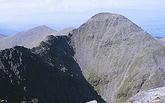
 Beenkeragh as viewed from the summit of Carrauntoohil; with the Beenkeragh Ridge (left) | |
| Highest point | |
| Elevation | 1,008.2 m (3,308 ft)[1] |
| Prominence | 90.85 m (298.1 ft)[1] |
| Listing | Furth, Hewitt, Arderin, Simm, Vandeleur-Lynam |
| Coordinates | 52°00′24″N 9°44′46″W / 52.006802°N 9.746246°W[1] |
| Geography | |
| Parent range | MacGillycuddy's Reeks |
| OSI/OSNI grid | V801852 |
| Topo map | OSI Discovery 78 |
| Geology | |
| Mountain type(s) | Purple sandstone & siltstone, (Ballinskelligs Sandstone Formation)[1] |
| Climbing | |
| Easiest route | via Hag's Tooth Ridge |
Binn Chaorach (or Beenkeragh or Benkeeragh) (Irish: Binn Chaorach, meaning 'mountain of sheep')[2] is the second-highest peak in Ireland, at 1,008.2 metres (3,308 ft), on both the Arderin and Vandeleur-Lynam lists. It is part of the MacGillycuddy's Reeks range in County Kerry. Beenkeragh also gives its name the infamous Beenkeragh Ridge, the narrow rocky arete between Beenkeragh and Carrauntoohil, Ireland's highest mountain.
Geography
[edit]
Beenkeragh lies to the north of Carrauntoohil 1,038.6 metres (3,407 ft)., and is part of the MacGillycuddy's Reeks range in County Kerry. Beenkeragh is joined to Carrauntoohil by a very narrow rocky ridge, or arete, known as the Beenkeragh Ridge. In the middle of the Beenkeragh Ridge is another other summit called, The Bones (Irish: Na Cnámha) 957 metres (3,140 ft).[citation needed]
Beenkeragh is the 179th-highest mountain in Britain and Ireland on the Simm classification.[3] Beenkeragh is regarded by the Scottish Mountaineering Club ("SMC") as one of 34 Furths, which is a mountain above 3,000 ft (914 m) in elevation, and meets the other SMC criteria for a Munro (e.g. "sufficient separation"), but which is outside of (or furth) Scotland;[4] which is why Beenkeragh is sometimes referred to as one of the 13 Irish Munros.
Beenkeragh's prominence qualifies it to meet the Arderin classification, and the British Isles Simm and Hewitt classifications.[3] Beenkeragh does not appear in the MountainViews Online Database, 100 Highest Irish Mountains, as the prominence threshold is over 100 m (328 ft).[5]
Climbing
[edit]
The Beenkeragh Ridge is considered as offering some of Ireland's "most intimidating" hill-walking, and is often climbed as part of the Coomloughra Horseshoe, described as "one of Ireland's finest ridge-walks".[6] The horseshoe takes in Ireland's three highest mountains, Carrauntoohil, Beenkeragh, and Caher.[7]
Beenkeragh is also accessed from the south-east via the Hag's Glen by ascending the Hag's Tooth 650 metres (2,130 ft), and continuing up the steep and rocky Hag's Tooth Ridge to the summit of Beenkeragh. The route gives views into the deep corrie at the base of Carrauntoohil's north-east face, known as the Eagle's Nest area.[8] The Eagle's Nest corrie consists of three levels, with the top level (or third level), containing Lough Cummeenoughter, Ireland's highest lake.[9] On summiting Beenkeragh, the route crosses the Beenkeragh Ridge to Carrauntoohil and descends via the Heavenly Gates path across the east-face of Carrauntoohil.[7]
See also
[edit]- Lists of mountains in Ireland
- List of mountains of the British Isles by height
- List of Furth mountains in the British Isles
References
[edit]- ^ a b c d MountainViews: Beenkeragh
- ^ Paul Tempan (February 2012). "Irish Hill and Mountain Names" (PDF). MountainViews.ie.
- ^ a b Chris Cocker; Graham Jackson (2018). "The Database of British and Irish Hills". Database of British and Irish Hills.
- ^ Mountains – Key Facts. The Munros, Corbetts, Grahams, Donalds & Furths Archived 2012-08-22 at the Wayback Machine at www.smc.org.uk. Accessed on 5 Feb 2013.
- ^ Mountainviews, (September 2013), "A Guide to Ireland's Mountain Summits: The Vandeleur-Lynams & the Arderins", Collins Books, Cork, ISBN 978-1-84889-164-7
- ^ "THE COOMLOUGHRA HORSESHOE: THE BEENKERAGH RIDGE AND THE BONES PEAK". Aidan McGlynn. 15 December 2016.
The next stage would be to cross the notorious Beenkeragh Ridge, which spans the gap between Ireland's second highest peak – Beenkeragh, and its highest – Carrauntoohil. On the way, mid-ridge, is another high summit, The Bones Peak.
- ^ a b Ryan, Jim (2006). Carrauntoohil and MacGillycuddy's Reeks: A Walking Guide to Ireland's Highest Mountains. Collins Press. ISBN 978-1905172337.
- ^ John Dwyer (5 June 2010). "Plenty of bite in the Hag's Tooth". Irish Times.
- ^ Helen Fairborn (30 June 2018). "Fancy a swim in Ireland's highest lake, halfway up Carrauntoohil?". Irish Times.
Located at an elevation of 707m, Lough Cummeenoughter in Co Kerry is a unique swimming spot. Not only is this the highest lake in Ireland, it's also one of the most dramatic. Nestled at the base of a natural amphitheatre with the country's two tallest peaks towering on either side, Irish swimming doesn't come any wilder than this. The lake itself is surprisingly hospitable; it has a sandy bed and becomes deep quickly enough to dive into.
External links
[edit]- MountainViews: The Irish Mountain Website, Beenkeragh
- MountainViews: Irish Online Mountain Database
- The Database of British and Irish Hills , the largest database of British Isles mountains ("DoBIH")
- Hill Bagging UK & Ireland, the searchable interface for the DoBIH
- Logainm: Placenames Database of Ireland


