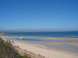
Baudin Beach, South Australia
| Baudin Beach South Australia | |||||||||||||||
|---|---|---|---|---|---|---|---|---|---|---|---|---|---|---|---|
 Baudin Beach, Kangaroo Island | |||||||||||||||
| Coordinates | 35°47′00″S 137°50′00″E / 35.7834°S 137.8334°E | ||||||||||||||
| Population | 319 (shared with other localities in the “State Suburb of Island Beach”) (2011 census)[1][a] | ||||||||||||||
| Established | 2002[2] | ||||||||||||||
| Postcode(s) | 5222[3] | ||||||||||||||
| Location | |||||||||||||||
| LGA(s) | Kangaroo Island Council | ||||||||||||||
| Region | Fleurieu and Kangaroo Island[4] | ||||||||||||||
| County | Carnarvon[2] | ||||||||||||||
| State electorate(s) | Mawson[5] | ||||||||||||||
| Federal division(s) | Mayo[6] | ||||||||||||||
| |||||||||||||||
| |||||||||||||||
| Footnotes | Locations[3] Climate[7] Adjoining localities[2] | ||||||||||||||
Baudin Beach is a locality in the Australian state of South Australia located on Dudley Peninsula on the north coast of Kangaroo Island about 115 kilometres (71 miles) south of the capital city of Adelaide and about 12 kilometres (7.5 miles) west of Penneshaw. It is named in 2002 after the French navigator Nicolas Baudin in honor of his exploration of Kangaroo Island in 1802.[3][2]
Prior to 2002, Baudin Beach was known as American Beach, being the name given to the land subdivision of the area in 1966. The name was changed in 2002 to avoid confusion with the originally named American Beach which is located a short distance north of the subdivision.[2] The area was once known as Deep Creek Farm, owned by Bruce Bates of Penneshaw.[8] Bates sold the land to Clem Bessell in 1966, who in conjunction with real estate agent Cliff Hawkins subdivided the area which is still often referred to as "Bessell's".[citation needed]
The name Baudin Beach was officially gazetted in March 2002.[9]
Baudin Beach comprises 207 allotments,[10] each mainly in excess of 800 square metres. Some 30% of the allotments are a mix of permanent and holiday homes, the remaining allotments being undeveloped.[11]
There are no shopping facilities in Baudin Beach and there is no reticulated water supply.[citation needed] Next to the proposed boat ramp is a copper sculpture, unveiled in 2002, of Mary Beckwith, reputedly the first recorded European woman to set foot on South Australian soil.[citation needed][12]
The waters of Eastern Cove immediately adjoining Baudin Beach are renowned for King George whiting.[citation needed]
Baudin Beach is located within the federal division of Mayo, the state electoral district of Mawson and the local government area of the Kangaroo Island Council.[2][5][6]
References
[edit]- Notes
- ^ For the 2011 census, the State Suburb of Island Beach covered the full extent of the Dudley Peninsula with the exception of Penneshaw - refer Dudley Peninsula#Demographics for more information
- Citations
- ^ Australian Bureau of Statistics (31 October 2012). "Island Beach". 2011 Census QuickStats. Retrieved 20 April 2016.
- ^ a b c d e f "Search result for "Baudin Beach (Locality Bounded)" (Record no SA0048036) with the following layers selected - "Suburbs and Localities" and "Local Government Areas"". Department of Planning, Transport and Infrastructure. Archived from the original on 12 October 2016. Retrieved 20 April 2016.
- ^ a b c "Postcode for Baudin Beach, South Australia". postcodes-australia.com. Retrieved 24 May 2016.
- ^ "Fleurieu and Kangaroo Island SA Government region" (PDF). The Government of South Australia. Archived from the original (PDF) on 21 March 2019. Retrieved 9 September 2016.
- ^ a b Mawson (Map). Electoral District Boundaries Commission. 2016. Retrieved 2 March 2018.
- ^ a b "Federal electoral division of Mayo, boundary gazetted 16 December 2011" (PDF). Australian Electoral Commission. Retrieved 2 August 2015.
- ^ "Monthly climate statistics: Summary statistics CAPE WILLOUGHBY (nearest station)". Commonwealth of Australia, Bureau of Meteorology. Retrieved 7 May 2016.
- ^ "Baudin Beach ... a brief history". The Fig Tree. Archived from the original on 18 July 2008. Retrieved 2008-07-28.
- ^ "THE SOUTH AUSTRALIAN GOVERNMENT GAZETTE" (PDF). Government of South Australia. 7 March 2002. p. 1152. Archived from the original (PDF) on 21 June 2009. Retrieved 28 August 2015.
- ^ Lands Titles Office, Filed Plans 7761,7762
- ^ Kangaroo Island Assessment Book
- ^ SA Central. "Kangaroo Island Beaches". Archived from the original on 5 September 2007. Retrieved 12 July 2007.

