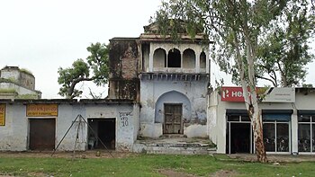
Barauli Rao
Barauli Rao | |
|---|---|
Town | |
| Coordinates: 27°02′43″N 79°58′59″E / 27.04528°N 79.98306°E | |
| Country | |
| State | Uttar Pradesh |
| District | Aligarh |
| Population | |
• Total | 50,000 |
| Language | |
| • Official | Hindi[1] |
| • Additional official | Urdu[1] |
| Time zone | UTC+5:30 (IST) |
| PIN | 202126 |
| Telephone code | 248 |
| Lok Sabha constituency | Aligarh |
Barauli Rao is a town, panchayat block and Vidhansabha constituency in Aligarh district in the Indian state of Uttar Pradesh.
Geography
[edit]It is situated 25 km from Aligarh city, 15 km from Qasimpur Power House Colony and 20 km distance from Harduaganj Thermal Power Station. Barauli Rao is located on the west side of Aligarh.
History
[edit]


Barauli was a jagir during British India.[2][3]
The title of Rao was first used by Raja Pratap Singh, the founder king of Barauli state. Bargujar Rajput's Bajgarhi state at the time of Raja Pirthi Raj and was prefixed to the name of the eldest son Rao Raja Raghuraj Singh. In 1931 title of Rao of Barauli was made hereditary by British.[2]
- Rao Karan Singh had adopted his grandson (Raj Kunwar), who was his daughter's and Rao Raghuraj Singh's son, the ruler of Bajgarhi estate, Aligarh.
- Rao Raj Kunwar Singh, M.L.A., the last Zamindar of Barauli Estate
Demographics
[edit]As of 2001[update] India census,[4] Barauli Rao had a population of 5,000. Males constitute 70% of the population and females 30%. Barauli Rao has an average literacy rate of 20%. 15% of the population is under 6 years of age.
Education
[edit]Barauli Rao has many schools and one college, Barauli Inter College.
Services
[edit]Barauli Rao has 3 bank, Gramin Bank[5] Punjab National Bank and the State Bank of India.
See also
[edit]References
[edit]- ^ a b "52nd Report of the Commissioner for Linguistic Minorities in India" (PDF). nclm.nic.in. Ministry of Minority Affairs. Archived from the original (PDF) on 25 May 2017. Retrieved 26 December 2018.
- ^ a b Mann, Michael (1999). British Rule on Indian Soil: North India in the First Half of the Nineteenth Century. Manohar Publishers & Distributors. pp. 200–201. ISBN 978-81-7304-271-3. Retrieved 28 July 2021.
- ^ Ahmad, Ateeque (2006). System of Rural Settlements in India: A Histogenetic Perspective. Icon Publications. p. 79. ISBN 978-81-88086-30-6. Retrieved 28 July 2021.
- ^ "Census of India 2001: Data from the 2001 Census, including cities, villages and towns (Provisional)". Census Commission of India. Archived from the original on 16 June 2004. Retrieved 1 November 2008.
- ^ "Dead link". Yahoo. Retrieved 15 May 2018.


