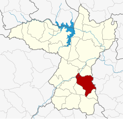
Ban Phai district
Ban Phai
บ้านไผ่ | |
|---|---|
 District location in Khon Kaen province | |
| Coordinates: 16°3′36″N 102°43′51″E / 16.06000°N 102.73083°E | |
| Country | Thailand |
| Province | Khon Kaen |
| Area | |
• Total | 477.7 km2 (184.4 sq mi) |
| Population (2007) | |
• Total | 101,031 |
| • Density | 211.5/km2 (548/sq mi) |
| Time zone | UTC+7 (ICT) |
| Postal code | 40110 |
| Geocode | 4010 |
Ban Phai (Thai: บ้านไผ่, pronounced [bâːn pʰàj]; Northeastern Thai: บ้านไผ่, pronounced [bâːn pʰāj]) is a district (amphoe) of Khon Kaen province, northeastern Thailand.
Geography
[edit]Neighboring districts are (from the south clockwise): Pueai Noi, Nong Song Hong, Non Sila, Chonnabot, Mancha Khiri, and Ban Haet of Khon Kaen Province; Kosum Phisai and Kut Rang of Maha Sarakham province.
History
[edit]Originally named Ban Keng (บ้านเกิ้ง), the area was at first a subdistrict (tambon) of Chonnabot district. In 1928 the minor district (king amphoe) Ban Phai was established consisting of three subdistricts split off from Chonnabot.[1] It was upgraded to a full district on 1 February 1940.[2] In 1946 Chonnabot was downgraded to be a part of Ban Phai District, until it was reestablished in 1966.
Economy
[edit]As of 2019[update], Thai sugar giant, the Mitr Phol Group, plans to construct a sugarcane mill and biomass power plant in the district. The initiative will occupy 4,000 rai (640 ha; 1,600 acres) of three of the province's neighbouring districts: Ban Phai, Chonnabot, and Non Sila. The operation will form part of the Ban Phai Bio-Hub Industrial Estate and is linked to the Eastern Economic Corridor (EEC) project. Mitr Phol's plans have been met with some opposition from local residents.[3] Mitr Phol has pledged that the factory will have no adverse environmental effects.[4]
Administration
[edit]The district is divided into 10 subdistricts (tambons), which are further subdivided into 113 villages (mubans). Ban Phai is a town (thesaban mueang) which covers parts of tambons Ban Phai, Khaen Nuea, and Nai Mueang. There are a further 10 tambon administrative organizations (TAO).
| No. | Name | Thai name | Villages | Pop. | |
|---|---|---|---|---|---|
| 1. | Ban Phai | บ้านไผ่ | 13 | 17,858 | |
| 2. | Nai Mueang | ในเมือง | 9 | 26,566 | |
| 5. | Mueang Phia | เมืองเพีย | 13 | 9,634 | |
| 9. | Ban Lan | บ้านลาน | 15 | 8,768 | |
| 10. | Khaen Nuea | แคนเหนือ | 9 | 6,973 | |
| 11. | Phu Lek | ภูเหล็ก | 8 | 5,966 | |
| 13. | Pa Po | ป่าปอ | 9 | 7,505 | |
| 14. | Hin Tang | หินตั้ง | 11 | 7,864 | |
| 16. | Nong Nam Sai | หนองน้ำใส | 11 | 6,246 | |
| 17. | Hua Nong | หัวหนอง | 6 | 3,651 |
Missing numbers are subdistricts which now form Ban Haet and Non Sila Districts.
References
[edit]- ^ แจ้งความกระทรวงมหาดไทย เรื่อง ตั้งกิ่งอำเภอบ้านไผ่ (PDF). Royal Gazette (in Thai). 45 (ง): 245–246. 1928-04-22. Archived from the original (PDF) on May 24, 2012.
- ^ ประกาศสำนักนายกรัฐมนตรี เรื่อง ยกฐานะกิ่งอำเภอบ้านไผ่ ขึ้นอำเภอชนบท จังหวัดขอนแก่น ขึ้นเป็นอำเภอ ขนานนามว่า อำเภอบ้านไผ่ (PDF). Royal Gazette (in Thai). 56 (ง): 3321. 1940-02-05. Archived from the original (PDF) on May 24, 2012.
- ^ Vaikuntapathi, Priya (25 September 2019). "Sweetness & Power (14) – Picking a fight with Big Sugar". The Isaan Record. Retrieved 26 November 2019.
- ^ "Mitr Phol pledges no environmental effects from new Khon Kaen factory". The Nation. 3 October 2019. Retrieved 26 November 2019.
External links
[edit]- amphoe.com (Thai)
