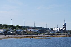
Baie-des-Sables
Baie-des-Sables | |
|---|---|
 | |
 Location within La Matanie RCM | |
| Coordinates: 48°43′N 67°51′W / 48.717°N 67.850°W[1] | |
| Country | Canada |
| Province | Quebec |
| Region | Bas-Saint-Laurent |
| RCM | La Matanie |
| Constituted | January 1, 1859 |
| Government | |
| • Mayor | Gérald Beaulieu |
| • Federal riding | Haute-Gaspésie—La Mitis—Matane—Matapédia |
| • Prov. riding | Matane-Matapédia |
| Area | |
• Total | 65.37 km2 (25.24 sq mi) |
| • Land | 65.07 km2 (25.12 sq mi) |
| Population | |
• Total | 613 |
| • Density | 9.4/km2 (24/sq mi) |
| • Pop (2016-21) | |
| • Dwellings | 336 |
| Time zone | UTC−5 (EST) |
| • Summer (DST) | UTC−4 (EDT) |
| Postal code(s) | |
| Area codes | 418 and 581 |
| Highways | |
| Website | www |
Baie-des-Sables is a municipality in La Matanie Regional County Municipality in the Bas-Saint-Laurent region of Quebec, Canada.
Its elevation is 176 metres (577 ft).[citation needed]
History
[edit]The area was originally part of the Mitis seignory, purchased by Mathew MacNider in 1802, and acquired by his brother John MacNider in 1807. MacNider encouraged settlement of Scottish families there. Upon John Macnider's death in 1829, the seignory was inherited by the 2 sons of Adam Lymburner Macnider, nephew of John. In 1842, the geographic township of MacNider was created.[4]
In 1853, the Mission of L'Assomption-de-Notre-Dame was established, and in 1859, the Township Municipality of MacNider was formed when it ceded from the Municipality of Métis. In 1864, the MacNider Post Office opened.[1][5]
The Scottish settlers began to call the place Sandy Bay, or also Sandy Beach, in reference to a prominent sandbank on the western edge of the municipality. In 1902, the post office was renamed to Sandy Bay, and renamed to the French equivalent, Baie-des-Sables, in 1925. In 1932, the township municipality followed suit and changed name and statutes from Township Municipality of MacNider to the Municipality of Baie-des-Sables.[1][5]
Demographics
[edit]| 2021 | 2016 | 2011 | |
|---|---|---|---|
| Population | 613 (-2.4% from 2016) | 628 (3.1% from 2011) | 609 (-0.8% from 2006) |
| Land area | 65.07 km2 (25.12 sq mi) | 65.19 km2 (25.17 sq mi) | 65.48 km2 (25.28 sq mi) |
| Population density | 9.4/km2 (24/sq mi) | 9.6/km2 (25/sq mi) | 9.3/km2 (24/sq mi) |
| Median age | 56.0 (M: 56.4, F: 56.0) | 51.9 (M: 51.7, F: 52.5) | 48.5 (M: 47.5, F: 48.96) |
| Private dwellings | 336 (total) 281 (occupied) | 328 (total) | 277 (total) |
| Median household income | $58,000 | $51,840 | $48,415 |
|
|
| |||||||||||||||||||||||||||||||||||||||||||||||||||||||||||||||||||||||||||||||||
| Population counts are not adjusted for boundary changes. Source: Statistics Canada[11] | |||||||||||||||||||||||||||||||||||||||||||||||||||||||||||||||||||||||||||||||||||
Language
[edit]Mother tongue language (2021)[12]
| Language | Population | Pct (%) |
|---|---|---|
| French only | 605 | 98.4% |
| English only | 0 | 0.0% |
| Both English and French | 5 | 0.8% |
| Other languages | 0 | 0.0% |
Government
[edit]Local government
[edit]List of former mayors:[5]
- Olivier Côté (1859–1862)
- Alexis Caron (1862–1864)
- Auguste Lamontagne (1864–1867)
- Georges Bélanger (1867–1868, 1889–1892)
- Louis Saucier (1868–1883)
- Achille Chouinard (1883–1886)
- Louis Martial Raymond (1886–1889)
- François Parent (1892–1893)
- Jean-Baptiste Pinault (1893–1894)
- Théophile Fournier (1894–1898)
- Georges Boucher (1898–1904)
- François St-Laurent (1904–1905)
- Thomas Santerre (1905–1910)
- Israël Michaud (1910–1919, 1923–1931, 1933–1935)
- Michel Crispo (1919–1920)
- Joseph Thibault (1920–1923)
- Octave Massé (1931–1933)
- J. Honoré Desrosiers (1935–1936)
- J. Antoine Santerre (1936–1951)
- Donald Mac Donald (1951–1955)
- Philippe Morin (1955–1963)
- Roland Massé (1963–...)
- Jacques Couillard (...–2009)
- Denis Santerre
- Gérald Beaulieu (2021–present)
See also
[edit]References
[edit]- ^ a b c "Banque de noms de lieux du Québec: Reference number 3060". toponymie.gouv.qc.ca (in French). Commission de toponymie du Québec.
- ^ a b "Répertoire des municipalités: Geographic code 08080". www.mamh.gouv.qc.ca (in French). Ministère des Affaires municipales et de l'Habitation. Retrieved 2024-09-04.
- ^ a b "Baie-des-Sables census profile". 2021 Census data. Statistics Canada. Retrieved 2022-11-07.
- ^ "Banque de noms de lieux du Québec: MacNider (canton)". toponymie.gouv.qc.ca (in French). Commission de toponymie du Québec. Retrieved 2024-09-04.
- ^ a b c "Répertoire des entités géopolitiques: Baie-des-Sables (municipalité) 1.1.1859 - ..." www.mairesduquebec.com. Institut généalogique Drouin. Retrieved 4 September 2024.
- ^ "2021 Community Profiles". 2021 Canadian census. Statistics Canada. February 4, 2022. Retrieved 2023-10-19.
- ^ "2016 Community Profiles". 2016 Canadian census. Statistics Canada. August 12, 2021. Retrieved 2022-11-07.
- ^ "2011 Community Profiles". 2011 Canadian census. Statistics Canada. March 21, 2019. Retrieved 2014-01-29.
- ^ "2006 Community Profiles". 2006 Canadian census. Statistics Canada. August 20, 2019.
- ^ "2001 Community Profiles". 2001 Canadian census. Statistics Canada. July 18, 2021.
- ^ "1971 Census of Canada - Population Census Subdivisions (Historical)". Catalogue 92-702 Vol I, Part 1 (Bulletin 1.1-2). Statistics Canada: 76, 139. July 1973.
- ^ 2021 Statistics Canada Community Profile: Baie-des-Sables, Quebec

