International Rhine Regulation Railway
| International Rhine Regulation Railway | ||||||||||||||||||||||||||||||||||||||||||||||||||||||||||||||||||||||||||||||||||||||||||||||||||||||||||||||
|---|---|---|---|---|---|---|---|---|---|---|---|---|---|---|---|---|---|---|---|---|---|---|---|---|---|---|---|---|---|---|---|---|---|---|---|---|---|---|---|---|---|---|---|---|---|---|---|---|---|---|---|---|---|---|---|---|---|---|---|---|---|---|---|---|---|---|---|---|---|---|---|---|---|---|---|---|---|---|---|---|---|---|---|---|---|---|---|---|---|---|---|---|---|---|---|---|---|---|---|---|---|---|---|---|---|---|---|---|---|---|
 The railway bridge at Kriessern in 2011, photographed from Switzerland with Austria in the background | ||||||||||||||||||||||||||||||||||||||||||||||||||||||||||||||||||||||||||||||||||||||||||||||||||||||||||||||
| Overview | ||||||||||||||||||||||||||||||||||||||||||||||||||||||||||||||||||||||||||||||||||||||||||||||||||||||||||||||
| Locale | Austria, Province of Vorarlberg Switzerland, Canton of St Gallen | |||||||||||||||||||||||||||||||||||||||||||||||||||||||||||||||||||||||||||||||||||||||||||||||||||||||||||||
| Technical | ||||||||||||||||||||||||||||||||||||||||||||||||||||||||||||||||||||||||||||||||||||||||||||||||||||||||||||||
| Line length | 25 km (16 mi) | |||||||||||||||||||||||||||||||||||||||||||||||||||||||||||||||||||||||||||||||||||||||||||||||||||||||||||||
| Track gauge | 750 mm (2 ft 5+1⁄2 in) | |||||||||||||||||||||||||||||||||||||||||||||||||||||||||||||||||||||||||||||||||||||||||||||||||||||||||||||
| Electrification | 750 V DC | |||||||||||||||||||||||||||||||||||||||||||||||||||||||||||||||||||||||||||||||||||||||||||||||||||||||||||||
| ||||||||||||||||||||||||||||||||||||||||||||||||||||||||||||||||||||||||||||||||||||||||||||||||||||||||||||||
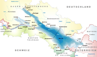
The International Rhine Regulation Railway (German: Internationale Rheinregulierungsbahn) was an industrial railway situated on both banks of the Alpine Rhine canal to the south of its outfall into Lake Constance. As this stretch of the River Rhine forms the border between Austria and Switzerland, the railway is located in both countries (further north the border follows westwards along the Alter Rhein). Large parts of the system have been preserved, and part of the tracks are used as heritage railway.[1]
Infrastructure
[edit]The railway opened in 1892. It is constructed to 750 mm gauge (2 ft 5+1⁄2 in gauge) and is partially electrified at 750 V DC using overhead lines. As its name suggests, the railway's original purpose was to assist in the engineering works needed to regulate the Rhine in this area - the so-called Rhine Regulation. Rocks from nearby quarries were used to build and reinforce the levees along the river (today, transportation of rocks to the levees is done using trucks).[2]
Current use
[edit]In 2006, the then 33 km (21 mi) long line was closed for industrial use. Some of the tracks, mainly on the left bank of the river, have been subsequently removed, including the bridge at Kriessern in 2020.[3] However, most of the line remains. Part of the tracks were converted to a heritage railway. Since 2008, operations on the line between Lustenau (where a small platform was built) and the river outflow are done by the Verein Rheinschauen (Rheinschauen association), which also conducts maintenance work on the line.[2] Diesel-electric locomotives push-pulling passenger coaches operate on weekends during the warmer seasons.[4]
Gallery
[edit]-
Heritage train on the Wiesenrain bridge over the Alpine Rhine
-
Heritage train on the Wiesenrain bridge over the Alpine Rhine
-
Heritage train "Nikolaus" in 2007
-
Tracks in Lustenau
-
Route section near Hard in 2009
-
Tracks under Fussach-Hard bridge
See also
[edit]References
[edit]- ^ "Strecke" [Route] (in German). Rhein-Schauen. Archived from the original on 29 May 2014. Retrieved 28 May 2014.
- ^ a b "Die Internationale Rheinregulierungsbahn". alpenbahnen.net (in German). Retrieved 28 May 2014.
- ^ "Abbruch der Rhein-Brücke Kriessern/Mäder [Demolition of the Rhine bridge between Kriessern and Mäder]" (in German). 13 March 2020. Retrieved 12 May 2024.
- ^ "Rhein-Schauen (Fahrplan & Events)" (in German). Retrieved 9 May 2024.
External links
[edit] Media related to International Rhine Regulation Railway at Wikimedia Commons
- Rhein-Shauen; Museum und Rheinbänle - the society that preserves the railway
47°26′52″N 9°39′41″E / 47.4478°N 9.6614°E
- 750 mm gauge railways in Austria
- 750 mm gauge railways in Switzerland
- Heritage railways in Austria
- Closed railway lines in Switzerland
- Cross-border railway lines in Austria
- Cross-border railway lines in Switzerland
- Railway lines in Austria
- Railway lines in Switzerland
- Transport in Vorarlberg
- 750 V DC railway electrification
- Europe rail transport stubs
- Austria transport stubs
- Switzerland transport stubs


