Konotop
This article needs additional citations for verification. (June 2019) |
You can help expand this article with text translated from the corresponding article in Ukrainian. (October 2015) Click [show] for important translation instructions.
|
Konotop
Конотоп | |
|---|---|
 Counterclockwise (from upper right): Shukhov Tower, Myr Cinema, Ascension Cathedral, Konotop City Council Building, Konotop railway station and tram, Monument of Horse | |
| Coordinates: 51°13′N 33°12′E / 51.217°N 33.200°E | |
| Country | |
| Oblast | Sumy Oblast |
| Raion | Konotop Raion |
| Hromada | Konotop urban hromada |
| Founded | 1634 |
| Government | |
| • Mayor | Artem Semenikhin (Svoboda) |
| Area | |
• Total | 43.78 km2 (16.90 sq mi) |
| Elevation | 142 m (466 ft) |
| Population (2022) | |
• Total | 83,543 |
| Time zone | UTC+2 (EET) |
| • Summer (DST) | UTC+3 (EEST) |
| Postal codes | 41600–41615 |
| Area code | +380 5447 |
| Website | Official website |
Konotop (Ukrainian: Конотоп, IPA: [konoˈtɔp] ) is a city in Sumy Oblast, northeastern Ukraine. Konotop serves as the administrative center of Konotop Raion within the oblast. Konotop is located about 129 kilometres (80 mi) from Sumy, the administrative center of the oblast. It is host to Konotop Air Base. The population is 83,543 (2022 estimate).[1]
History
[edit]During the beginning of the 17th century, Cossacks were first based in that area. The settlement was first mentioned in 1634 in various documents as Novoselytsia. In 1642 a Polish fortress was built in that place, named after the river Konotopka. Probably the river disappeared, and another one was created, Yezuch. The fortification became a key point in the struggle against the Moscow state.
Another hypothesis is that the name of the city could originate[2] from the name of the ancient Warmian knyaz (князь) Christopher of Kononowitz of the noble Polish-Belarusian-Lithuanian family Kononowicz-Piłsudski that still exists and uses the Polish coat of arms of Radwan. The name "Konotop" would then mean “the place of Kono(nowitz)” from adjoining the suffix topos (cf. Ancient Greek τόπος) meaning place or location.
In 1659 the Battle of Konotop took place near the city, in which Cossacks led by Ivan Vyhovsky (allied with Poles and Crimean Tatars) defeated Muscovite forces. In 1782 Konotop was granted municipal rights.[3]
During World War II, Konotop was occupied by the German Army from 3 September 1941 to 6 September 1943. Details of this are recounted in the book The Forgotten Soldier by Guy Sajer. The Germans operated a Nazi prison and the Stalag 310 prisoner-of-war camp in the city.[4][5]
2022 Russian invasion of Ukraine
[edit]On 25 February 2022, during the 2022 Russian invasion of Ukraine, the city was reported to be under siege by Russian forces on their way to Kyiv.[6] Ukraine later stated that it had lost control of the city.[7] The mayor Artem Seminikhin stated on 2 March that Russian troops who had entered the city had warned him that they would destroy the city if the residents resisted them.[8] An agreement was reached under which Russian forces accepted not to change the city's government or deploy troops, in return for which the residents would not attack them.[9] On 3 April, Ukrainian MP Oleksandr Kachura stated on Twitter that all Russian forces had left Konotop Raion.[10] On 4 April 2022 Sumy Oblast's Governor Dmytro Zhyvytskyi stated that Russian troops no longer occupied any towns or villages in Sumy Oblast and had mostly withdrawn, while Ukrainian troops were working to push out the remaining units.[11]
Demographics
[edit]Ethnicty
[edit]As of the 2001 Ukrainian census, Konotop had a population of 93,365 inhabitants. The ethnic and linguistic population was as follows:[12][13]
Economy
[edit]The main industrial enterprises of the city include the Konotop Casting and Mechanical Plant, the Motordetal Plant, the Konotop Fittings Plant, the Konotop Car Repair Plant, the Aviakon Aircraft Repair Plant, a mechanical plant, a garment factory, a meat processing plant (Konotopmyaso OJSC), a dairy plant, and a bakery plant. Konotop is an important mechanical engineering center, food production center.
Transport
[edit]The city is an important transportation center. Various railroad connections from Konotop include: Moscow–Kyiv, Simferopol–Minsk, Bakhmach–Kyiv, Bryansk–Sumy/Belgorod. Furthermore, Konotop is one of the smallest cities in the country with its own tram system.
Geography
[edit]Climate
[edit]| Climate data for Konotop (1991–2020, extremes 1948–present) | |||||||||||||
|---|---|---|---|---|---|---|---|---|---|---|---|---|---|
| Month | Jan | Feb | Mar | Apr | May | Jun | Jul | Aug | Sep | Oct | Nov | Dec | Year |
| Record high °C (°F) | 8.4 (47.1) |
14.0 (57.2) |
22.5 (72.5) |
29.9 (85.8) |
33.1 (91.6) |
35.8 (96.4) |
35.9 (96.6) |
39.0 (102.2) |
35.0 (95.0) |
27.2 (81.0) |
18.0 (64.4) |
12.6 (54.7) |
39.0 (102.2) |
| Mean daily maximum °C (°F) | −2.1 (28.2) |
−0.9 (30.4) |
5.0 (41.0) |
14.3 (57.7) |
21.0 (69.8) |
24.4 (75.9) |
26.4 (79.5) |
25.7 (78.3) |
19.4 (66.9) |
12.0 (53.6) |
4.0 (39.2) |
−0.8 (30.6) |
12.4 (54.3) |
| Daily mean °C (°F) | −4.5 (23.9) |
−3.8 (25.2) |
1.1 (34.0) |
9.1 (48.4) |
15.3 (59.5) |
19.0 (66.2) |
20.7 (69.3) |
19.6 (67.3) |
13.9 (57.0) |
7.5 (45.5) |
1.5 (34.7) |
−2.9 (26.8) |
8.0 (46.4) |
| Mean daily minimum °C (°F) | −6.9 (19.6) |
−6.6 (20.1) |
−2.4 (27.7) |
4.3 (39.7) |
9.7 (49.5) |
13.7 (56.7) |
15.4 (59.7) |
13.9 (57.0) |
9.0 (48.2) |
3.8 (38.8) |
−0.8 (30.6) |
−5.1 (22.8) |
4.0 (39.2) |
| Record low °C (°F) | −32.9 (−27.2) |
−32.2 (−26.0) |
−26.1 (−15.0) |
−12.2 (10.0) |
−3.7 (25.3) |
2.8 (37.0) |
6.1 (43.0) |
3.8 (38.8) |
−4.1 (24.6) |
−9.2 (15.4) |
−22.8 (−9.0) |
−28.9 (−20.0) |
−32.9 (−27.2) |
| Average precipitation mm (inches) | 46 (1.8) |
37 (1.5) |
37 (1.5) |
37 (1.5) |
59 (2.3) |
58 (2.3) |
71 (2.8) |
48 (1.9) |
47 (1.9) |
44 (1.7) |
42 (1.7) |
45 (1.8) |
571 (22.5) |
| Average extreme snow depth cm (inches) | 10 (3.9) |
13 (5.1) |
8 (3.1) |
0 (0) |
0 (0) |
0 (0) |
0 (0) |
0 (0) |
0 (0) |
0 (0) |
2 (0.8) |
6 (2.4) |
13 (5.1) |
| Average rainy days | 8 | 8 | 8 | 12 | 13 | 15 | 14 | 11 | 14 | 13 | 13 | 10 | 139 |
| Average snowy days | 19 | 17 | 11 | 2 | 0.1 | 0 | 0 | 0 | 0.1 | 2 | 10 | 18 | 79 |
| Average relative humidity (%) | 84.4 | 82.0 | 77.0 | 67.2 | 64.1 | 69.2 | 70.8 | 70.6 | 76.9 | 80.6 | 86.3 | 86.3 | 76.3 |
| Mean monthly sunshine hours | 42.5 | 69.1 | 139.9 | 190.6 | 283.2 | 272.6 | 288.8 | 267.1 | 170.0 | 110.1 | 40.6 | 30.5 | 1,905 |
| Source 1: Pogoda.ru.net[14] | |||||||||||||
| Source 2: World Meteorological Organization (humidity and sun 1981–2010)[15] | |||||||||||||
Notable people
[edit]- Bernard Meninsky, artist
Gallery
[edit]-
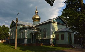
St. Nikolas wooden church
-
Ascension Church
-
Mansion of general Mikhail Dragomirov
-
Horse statue in the downtown
-
Old town
-
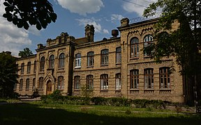
Konotop Railway Hospital
-
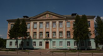
School in Konotop
-
Old school in Konotop
-
Konotop tram
-
Railway station
References
[edit]- ^ Чисельність наявного населення України на 1 січня 2022 [Number of Present Population of Ukraine, as of January 1, 2022] (PDF) (in Ukrainian and English). Kyiv: State Statistics Service of Ukraine. Archived (PDF) from the original on 4 July 2022.
- ^ "Въ лЂто 6478 [970] - 6494 [986]. Лаврентіївський літопис".
- ^ "Nazwiska".
- ^ "Gefängnis Konotop". Bundesarchiv.de (in German). Retrieved 2 April 2022.
- ^ "German Camps". Retrieved 2 April 2022.
- ^ "Russian Military Moves Towards Ukraine Capital". www.newsweek.com. 24 February 2022. Retrieved 2022-02-25.
- ^ Ward, Alexander. "'Almost not possible' for Ukraine to win without West's help, Ukraine official says". Politico. Archived from the original on 26 February 2022. Retrieved 2022-02-26.
- ^ Valeria Polischuk. "Мер Конотопа: місту поставили ультиматум - за опір накриють артилерією". RBC Ukraine (in Ukrainian). Retrieved 2022-02-25.
- ^ Natalia Gurkovskaya. "Бої на Сумщині – влада Конотопа провела переговори з окупантами після ультиматуму". RBC Ukraine (in Ukrainian). Retrieved 2022-02-25.
- ^ @SputnikATO (3 April 2022). "⚡️Конотопский район освобожден от российских оккупантов. Об этом сообщил нардеп Александр Качура.Еще вчера глава…" (Tweet) – via Twitter.
- ^ Russian troops no longer hold any settlements in Ukraine's Sumy region, says governor, National Post (4 April 2022)
- ^ "Національний склад міст".
- ^ "Рідні мови в об'єднаних територіальних громадах України".
- ^ "Климат Конотопа (Climate of Konotop)" (in Russian). Погода и климат (Weather and Climate). Archived from the original on 14 December 2019. Retrieved 8 November 2021.
- ^ "World Meteorological Organization Climate Normals for 1981–2010". World Meteorological Organization. Archived from the original on 17 July 2021. Retrieved 17 July 2021.
External links
[edit]- (in Ukrainian) Official website
- JewUa.org – History of Jewish Community in Konotop


