Arkansas Highway 21
 | ||||
| Route information | ||||
| Maintained by ArDOT | ||||
| Length | 99.14 mi[1] (159.55 km) | |||
| Existed | 1926–present | |||
| Major junctions | ||||
| South end | ||||
| North end | ||||
| Location | ||||
| Country | United States | |||
| State | Arkansas | |||
| Counties | Johnson, Newton, Madison, Carroll | |||
| Highway system | ||||
| ||||
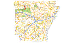
Arkansas Highway 21 (AR 21) is a north–south state highway in north central Arkansas. The route runs 99.14 miles (159.55 km) from U.S. Route 64 (US 64) in Clarksville north across US 62 to the Missouri state line.[2] The route is a two-lane highway with the exception of a brief concurrency with US 62, a four-lane highway, in Berryville.[1]
Route description
[edit]
The route begins at US 64 in Clarksville near the Clarksville Municipal Airport and runs north to the Ozark National Forest. Highway 21 runs north to intersect Highway 292 near Ludwig and Ludwig Lake near Hillcrest in Johnson County.[3] The route begins a concurrency with Highway 16[a 1] until Edwards Junction when Highway 21 turns north and serves as a southern terminus for Highway 43 at Boxley.[5] Upon entering Madison County, the highway intersects Highway 74 in Kingston and passes the Bank of Kingston, a property on the National Register of Historic Places.[6] Continuing north, Highway 21 intersects US 412 and enters Carroll County, before following US 412 for a short distance to the east, where it turns back north. The route continues north through Carroll County and enters Berryville, before a brief concurrency with US 62, followed by a concurrency with Highway 221, after which it heads north to the Missouri state line, where it continues as Missouri Route 13.
Ozark Highlands Scenic Byway
[edit]
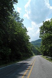
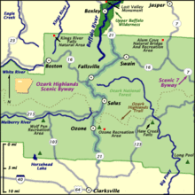
A portion of Highway 21 was designated as the Ozark Highlands Scenic Byway in 2005 by the Arkansas State Highway and Transportation Department (AHTD).[7] The byway begins at the southern terminus of Highway 21 at US 64 in Clarksville and runs north to the Buffalo National River near Boxley.[8] Wildlife and scenic views are frequent along the nearly 35-mile-long (56 km) route.[7] The highway is popular as a major route to the Ozark National Forest, the Ozark Highlands Trail, and the White River in addition to being the major travel route to cities in the area and points in southern Missouri.[9]
Major intersections
[edit]Mile markers reset at some concurrencies.
| County | Location | mi[1] | km | Destinations | Notes |
|---|---|---|---|---|---|
| Johnson | Clarksville | 0.00 | 0.00 | Southern terminus | |
| 0.41 | 0.66 | Western terminus of AR 164 | |||
| Ludwig | 2.99 | 4.81 | Western terminus of AR 292 | ||
| Hillcrest | |||||
| Newton | Fallsville | 28.13 | 45.27 | South end of AR 16 overlap | |
| Edwards Junction | 36.71 | 59.08 | North end of AR 16 overlap | ||
| Boxley | 48.04 | 77.31 | Southern terminus of AR 43 | ||
| Madison | Kingston | 57.45 | 92.46 | Roundabout; eastern terminus of AR 74 | |
| Carroll | | 64.66 | 104.06 | South end of US 412 overlap | |
| | 0.00 | 0.00 | North end of US 412 overlap | ||
| Berryville | 17.56 | 28.26 | South end of US 62 overlap | ||
| 0.00 | 0.00 | North end of US 62 overlap; south end of AR 221 overlap | |||
| 2.16 | 3.48 | North end of AR 221 overlap | |||
| Oak Grove | 12.55 | 20.20 | Northern terminus of AR 103 | ||
| Blue Eye | 16.67 | 26.83 | Northern terminus of AR 311 | ||
| 16.92 | 27.23 | Continuation into Missouri | |||
1.000 mi = 1.609 km; 1.000 km = 0.621 mi
| |||||
See also
[edit]Notes
[edit]- ^ Although Arkansas highways normally terminate when intersected by a route of greater importance, Highway 21 in Madison County does not end when intersecting Highway 16.[4]
References
[edit]- ^ a b c Planning and Research Division (2010). "Arkansas Road Log Database". Arkansas State Highway and Transportation Department. Archived from the original (Database) on 23 June 2011. Retrieved June 9, 2011.
- ^ General Highway Map, Carroll County, Arkansas (PDF) (Map). 1:62500. Cartography by Planning and Research Division. Arkansas State Highway and Transportation Department. 2010. Retrieved June 25, 2011.
- ^ General Highway Map, Johnson County, Arkansas (PDF) (Map). 1:62500. Cartography by Planning and Research Division. Arkansas State Highway and Transportation Department. 2010. Retrieved January 1, 2012.
- ^ Route and Section Map (PDF) (Map) (Newton County ed.). Arkansas State Highway and Transportation Department. Retrieved January 1, 2012.
- ^ General Highway Map, Newton County, Arkansas (PDF) (Map). 1:62500. Cartography by Planning and Research Division. Arkansas State Highway and Transportation Department. 2010. Archived from the original (PDF) on September 29, 2011. Retrieved January 1, 2012.
- ^ "National Register Information System". National Register of Historic Places. National Park Service. March 13, 2009.
- ^ a b "Highway 21/Ozark Highlands Scenic Byway". Arkansas State Highway and Transportation Department, Planning and Research Division. Retrieved January 9, 2012.
- ^ Map of Highway 21/Ozark Highlands Scenic Byway (PDF) (Map). Cartography by Planning and Research Division. Arkansas State Highway and Transportation Department. Retrieved January 9, 2012.
- ^ "Ozark Highlands Scenic Byway". Federal Highway Administration. Archived from the original on August 11, 2013. Retrieved January 9, 2012.
External links
[edit]![]() Media related to Arkansas Highway 21 at Wikimedia Commons
Media related to Arkansas Highway 21 at Wikimedia Commons

