Anûkathâ Îpa
| Anûkathâ Îpa | |
|---|---|
| Bald Eagle Peak | |
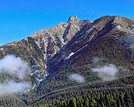
 Anûkathâ Îpa from Canmore | |
| Highest point | |
| Elevation | 2,514 m (8,248 ft)[1][2] |
| Prominence | 34 m (112 ft)[2] |
| Listing | Mountains of Alberta |
| Coordinates | 51°08′10″N 115°20′16″W / 51.13611°N 115.33778°W[3] |
| Naming | |
| English translation | Bald Eagle Peak |
| Language of name | North American Indian languages |
| Geography | |
 | |
| Interactive map of Anûkathâ Îpa | |
| Country | Canada |
| Province | Alberta |
| Parent range | Fairholme Range[2] |
| Topo map | NTS 82O3 Canmore[3] |
| Climbing | |
| Easiest route | Scramble[4] |
Anûkathâ Îpa (/ˌɑːnunˈkʌθɒ̃ imˈpə/ AH-noon-KUH-thə eem-PUH; Stoney Nakoda Anûkathâ Îpa[a] IPA: [ˌanũ'kʰaθã ĩ'pʰa][5][6][b], lit. transl. 'Bald Eagle Peak', sometimes written in English language sources as Anû Kathâ Îpa[7][c]) is an outlier of Mount Charles Stewart in the Canadian Rockies of Alberta. It is one of the most prominent landmarks in the vicinity of Canmore, Alberta.
Anûkathâ Îpa is the official name for the high point of a ridge that lies southwest of the Mount Charles Stewart summit and northwest of Mount Lady Macdonald near Canmore. The peak was formerly known by a racist and misogynistic nickname,[d] because of its resemblance to a woman's breast. It is part of a larger formation that has the appearance of a woman lying on her back, including a face, hair, and the general shape of a body, which adds to the resemblance.
On August 20, 2020 it was reported that the prominence would be renamed to avoid racist and misogynistic naming. The Stoney Nakoda people were asked to help select a culturally appropriate name and a request to support the initiative was brought to the Municipal District of Bighorn in September 2020.[8] It was officially renamed on September 29, 2020.[7]
Belonging to the Fairholme Range in Kananaskis Provincial Park, Anûkathâ Îpa is 1,200 metres (3,900 ft) above the Bow River valley. It is 2 km (1.2 mi) northwest of Lady Macdonald, just east of the Banff National Park gates.
Routes
[edit]For climbers, a scrambling route is graded moderate but includes exposure, so the ascent is not recommended in wet conditions. Climbers are advised to follow the major drainage ditch behind Harvie Heights and stay close along the right (south) side of the ditch, and then to follow this up to the North West ridge all the way to the slabs just below the summit.[4]
Gallery
[edit]-
Southwest aspect
See also
[edit]Notes
[edit]- ^ Note that the English spelling is borrowed directly from Stoney Nakoda, without clarification that the circumflexes indicate nasal vowels. Perhaps a more accurate Anglicized rendering would be Anoonkatha Eempah.
- ^ 'Corner' is the only definition listed for îpa in the Stoney Nakoda Dictionary Online at this time, but this word generally refers to objects that come to a point, such as a mountain peak. See also the closely related word îpta meaning 'tip, point'.
- ^ As seen and heard in the online dictionary, anûkathâ 'bald eagle' is typically understood to be a single word in Stoney Nakoda. Breaking up words into multiple parts is sometimes used to help learners and non-speakers achieve the correct pronunciation.[5]
- ^ "Squaw's Tit"
References
[edit]- ^ "Topographic map of Bald Eagle Peak". opentopomap.org. Retrieved 2021-10-31.
- ^ a b c "Anû Kathâ Îpa". Peakbagger.com. Retrieved 2021-07-11.
- ^ a b "Anû Kathâ Îpa (Bald Eagle Peak)". Geographical Names Data Base. Natural Resources Canada. Retrieved 2023-09-10.
- ^ a b Kane, Alan (2016). "The Tit". Scrambles in the Canadian Rockies (3rd ed.). Calgary: Rocky Mountain Books. Kindle Edition. ISBN 978-1-77160-098-9.
- ^ a b Stoney Nakoda Dictionary Online. "entry for anûkathâ (bald eagle)". dictionary.stoneynakoda.org. Retrieved 2023-08-08.
- ^ Stoney Nakoda Dictionary Online. "entry for îpa (corner, peak)". dictionary.stoneynakoda.org. Retrieved 2023-08-08.
- ^ a b "Beyond Local: Stoney Nakoda restores traditional name to peak with racist nickname". StAlbertToday.ca. September 29, 2020. Retrieved 2020-10-01.
- ^ Dulewich, Jenna (2020-08-20). "Moving Mountains: How Bow Valley is taking a stand against a peak with a racist name". rmotoday.com. Canmore, AB. Retrieved 2020-08-20.


