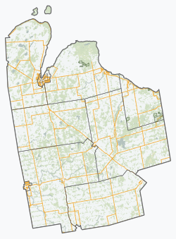
West Grey
West Grey | |
|---|---|
| Municipality of West Grey | |
 Durham, seat of and largest community in West Grey | |
| Coordinates: 44°11′N 80°49′W / 44.183°N 80.817°W | |
| Country | Canada |
| Province | Ontario |
| County | Grey |
| Formed | January 1, 2001 |
| Government | |
| • Mayor | Kevin Eccles |
| • Federal riding | Bruce—Grey—Owen Sound |
| • Prov. riding | Bruce—Grey—Owen Sound |
| Area | |
| • Land | 876.16 km2 (338.29 sq mi) |
| Population (2016)[1] | |
• Total | 12,518 |
| • Density | 14.3/km2 (37/sq mi) |
| Time zone | UTC−05:00 (EST) |
| • Summer (DST) | UTC−04:00 (EDT) |
| Postal Code | N0G 1R0 |
| Area code(s) | 519 and 226 |
| Website | www.westgrey.com |
West Grey is a municipality in the northern area of Southwestern Ontario, Canada, in Grey County spanning across the River Styx, the Rocky Saugeen River, the Beatty Saugeen River, and the South Saugeen River.
The municipality was formed by order of the Province of Ontario on January 1, 2001 when the former Townships of Bentinck, Glenelg, and Normanby, the Village of Neustadt, and the Town of Durham were amalgamated in a county-wide reorganization.
Communities
[edit]The Municipality of West Grey comprises the communities of Aberdeen, Allan Park, Alsfeldt, Ayton, Barrhead, Bentinck, Biemans Corners, Bunessan, Calderwood, Crawford, Durham, Edge Hill, Elmwood, Glen, Glenelg Centre, Habermehl, Hampden, Irish Lake, Lamlash, Lauderbach, Lauriston, Louise, Moltke, Mulock, Nenagh, Neustadt, Pomona, Priceville, Rocky Saugeen, Topcliff, Traverston, Vickers, Waudby and Welbeck.
Demographics
[edit]In the 2021 Census of Population conducted by Statistics Canada, West Grey had a population of 13,131 living in 5,284 of its 5,808 total private dwellings, a change of 4.9% from its 2016 population of 12,518. With a land area of 875.21 km2 (337.92 sq mi), it had a population density of 15.0/km2 (38.9/sq mi) in 2021.[2]
| Year | Pop. | ±% |
|---|---|---|
| 1996 | 11,499 | — |
| 2001 | 11,741 | +2.1% |
| 2006 | 12,193 | +3.8% |
| 2011 | 12,286 | +0.8% |
| 2016 | 12,518 | +1.9% |
| [3][4][1] | ||
Populations prior to amalgamation (2001):
- Population total in 1996: 11,499
- Bentinck (township): 3,597
- Durham (town): 2,641
- Glenelg (township): 2,136
- Neustadt (village): 568
- Normanby (township): 2,678
- Populations in 1991:
- Bentinck (township): 3,463
- Durham (town): 2,558
- Glenelg (township): 1,871
- Neustadt (village): 551
- Normanby (township): 2,797
West Grey has three elementary schools: Normanby Community School,[6] Spruce Ridge Community School,[7] and St. Peter's and St. Paul's Catholic School.[8] Public school education is managed by the Bluewater and District School Board[9] and Catholic schools are managed by the Bruce-Grey Catholic School Board.[10]
Healthcare
[edit]West Grey has one hospital in the Town of Durham: South Bruce Grey Health Centre,[11] Durham. The 10-bed hospital has an Emergency Department available 24-7, laboratory, pharmacy, and diagnostic services. The West Grey Medical Clinic provides services by family doctors and allied health professionals. The Clinic is owned and managed by the Durham Hospital Foundation.[12]
Services
[edit]Fire
[edit]West Grey Fire Department has three stations: Durham, Ayton, and Neustadt.
West Grey Public Library has three branches: Durham, Ayton, and Neustadt.
Unlike most rural communities, West Grey maintains its own police force, the West Grey Police Service with headquarters in the Town of Durham.
West Grey has a variety of halls and recreation centres across the municipality including: Ayton Centennial Hall, Durham Community Centre, Durham Town Hall, Elmwood Community Centre, Glenel Hall, Lamlash Hall, Neustadt Arena, Neustadt Community Centre and Normanby Arena Complex. Enjoy swimming at the Durham Wading Pool[16] and the Middle Dam on the Saugeen River.
Transit
[edit]GOST [17](Guelph Owen Sound Transportation) is a public transportation service connecting people from Owen Sound to Guelph along Hwy 10 with a stop in Durham.
Saugeen Mobility and Regional Transit[18] (SMART) provides accessible transportation for people who cannot travel by conventional transit or taxi.
See also
[edit]References
[edit]- ^ a b c "Census Profile, 2016 Census: West Grey, Municipality". Statistics Canada. Retrieved June 14, 2019.
- ^ "Population and dwelling counts: Canada, provinces and territories, census divisions and census subdivisions (municipalities), Ontario". Statistics Canada. February 9, 2022. Retrieved March 31, 2022.
- ^ Statistics Canada: 1996, 2001, 2006 census
- ^ "West Grey census profile". 2011 Census of Population. Statistics Canada. 8 February 2012. Retrieved 2012-08-09.
- ^ "Schools and education". www.westgrey.com. 2020-09-28. Retrieved 2022-04-17.
- ^ "Home". nor.bwdsb.on.ca. Retrieved 2022-04-17.
- ^ "Home". spr.bwdsb.on.ca. Retrieved 2022-04-17.
- ^ "St. Peter & St. Paul's School". stp.bgcdsb.org. Retrieved 2022-04-17.
- ^ "Home". www.bwdsb.on.ca. Retrieved 2022-04-17.
- ^ "Bruce-Grey Catholic District School Board". www.bgcdsb.org. Retrieved 2022-04-17.
- ^ "South Bruce Grey Health Centre – Quality Health Care – Close to Home". Retrieved 2022-04-17.
- ^ "Our Clinic and Hospital | Durham Hospital Foundation". www.durhamfoundation.ca. Retrieved 2022-04-17.
- ^ "About the Library | West Grey Public Library". www.westgreylibrary.com. Retrieved 2022-04-17.
- ^ "West GreyPolice | Community Partners". Retrieved 2022-04-17.
- ^ "Facility and hall rentals". www.westgrey.com. 2021-12-14. Retrieved 2022-04-17.
- ^ "Parks and recreation". www.westgrey.com. 2022-04-13. Retrieved 2022-04-17.
- ^ "Guelph Owen Sound Transportation". www.owensound.ca. 2022-03-16. Retrieved 2022-04-17.
- ^ "Eligibility Policy". Saugeen Mobility. Retrieved 2022-04-17.


