Al-Mushrifah
Appearance
Al-Mushrifah
المشرفة Al-Mishirfeh | |
|---|---|
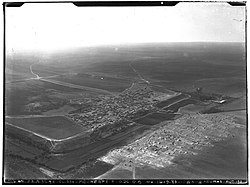
 1936 aerial view of Al-Mushrifah | |
| Coordinates: 34°50′04″N 36°51′03″E / 34.834479°N 36.850971°E | |
| Country | Syria |
| Governorate | Homs |
| District | Homs |
| Subdistrict | Ayn al-Niser |
| Population (2004) | |
• Total | 14,868 |
| Time zone | UTC+3 (EET) |
| • Summer (DST) | UTC+2 (EEST) |
Al-Mushrifah (Arabic: المشرفة, also spelled al-Mishirfeh, el-Mishrife or Musharrfeh) is a village in central Syria, administratively part of the Homs Governorate, located northeast of Homs, with a population of 14,868 in 2004. Nearby localities include Ayn al-Niser, Umm al-Amad and al-Mukharram to the east, and Talbiseh, al-Ghantu and Teir Maalah to the west. Outside the modern town is Tell el-Mishrife, the site of the ancient city-state of Qatna. It has a religiously mixed population of Sunni Muslims, Alawites and Christians. The village contains several mosques and two churches.[1]
In the 1950s, under the influence of the Syrian Communist Party, some of the peasants of al-Mushrifah rose against their landlord by seizing his harvest.[2]
References
[edit]- ^ Halabi, Alaa (2015-01-04). "Battles continue in Homs countryside". As-Safir. Al-Monitor.
- ^ Batatu, 1999, p. 121.
Bibliography
[edit]- Batatu, Hanna (1999). Syria's Peasantry, the Descendants of Its Lesser Rural Notables, and Their Politics. Princeton University Press. ISBN 0691002541.


