A4138 road
Appearance
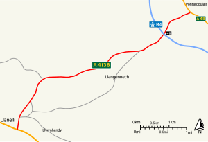
Route map:
(Redirected from A4138 road (Great Britain))
| A4138 | |
|---|---|
 | |
| Route information | |
| Length | 4.97 mi (8.00 km) |
| Major junctions | |
| East end | |
| West end | |
| Location | |
| Country | United Kingdom |
| Primary destinations | Llanelli |
| Road network | |
The A4138 is a main road in Carmarthenshire, Wales, connecting Pontarddulais with Llanelli. Running in a northeast to southwest direction, the road connects with M4 junction 48.[1] Northeast of the motorway, the road is classified as a non-primary route, while southwest of the motorway, the road is classified as a primary route. In both instances, the road is operated by Carmarthenshire County Council.
Proposals
[edit]- There have been proposals to make the southwestern section from the M4 to Llanelli a trunk road, which would be operated by the Welsh Government, but these have been rejected.[2]
- The local council has a policy to reject any planning application that would prevent or adversely affect the implementation of a dual carriageway between the M4 and Trostre.[3]
Places served
[edit]Settlements served by the road include:
References
[edit]KML is from Wikidata
- ^ Ordnance Survey. "1:50,000 Landranger Map". Retrieved 13 April 2012.
- ^ Carmarthenshire County Council (12 December 2002). "REVIEW OF TRUNK ROADS IN WALES 2002". Retrieved 13 April 2002.
- ^ "Carmarthenshire Council – Unitary Development Plan: Transportation". Carmarthenshire County Council. Archived from the original on 28 December 2013.


