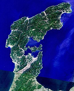
Noto Peninsula
Native name: 能登半島 | |
|---|---|
 Landsat image with high-resolution data from Space Shuttle | |
 Topographic map of Noto Peninsula | |
| Geography | |
| Location | Sea of Japan |
| Coordinates | 37°12′N 136°54′E / 37.2°N 136.9°E |
| Administration | |
Japan | |
| Prefecture | Ishikawa Prefecture |

The Noto Peninsula (能登半島, Noto-hantō) is a peninsula that projects north into the Sea of Japan from the coast of Ishikawa Prefecture in central Honshū, the main island of Japan. Before the Meiji era, the peninsula belonged to Noto Province. The main industries of the peninsula are agriculture, fisheries, and tourism.
Name
[edit]According to Alexander Vovin, the name is derived from Ainu not 'cape' or noto 'big cape'.[1] It is written with two ateji (ad hoc kanji used for an unrelated word): 能 nō 'ability' and 登 tō/to 'ascend'.
Area and spots
[edit]Three regions
[edit]The area of the Noto Peninsula is divided into three regions.
- Kuchi-Noto (Entrance of Noto)
- South part of the area. Hakui City, Kahoku City, Hōdatsu-shimizu Town, Shika Town
- Naka-Noto (Middle of Noto)
- Middle part of the area. Nanao City, Wakura Onsen Resort, Naka-Noto Town, Tatsuruhama
- Oku-Noto (Deep Noto or North Noto)
- North part of the area. Wajima City, Suzu City, Noto Town, Anamizu Town, Noto Island
In film
[edit]The Noto Peninsula features prominently in the Japanese film noir Zero Focus (Zero no Shoten, 1961), directed by Yoshitaro Nomura. The film features breathtaking footage of the peninsula's coast, along with an interesting dissection of the area's social distinctions. Noto Peninsula is also the setting of Hirokazu Koreeda's second film Maborosi (1995) and Shōhei Imamura's final film Warm Water Under a Red Bridge (Akai Hashi no Shita no Nurui Mizu, 2001). Suzu, the city located at the tip of the Noto Peninsula is the setting for the 2014 film Saihate Nite.
Transportation
[edit]- JR Nanao Line comes from Kanazawa to Wakura Onsen Station via Unoke, Hakui, Nanao.
- Noto Railway
- Small local railway from Wakura to Anamizu.
- Noto Airport
- Located between Anamizu and Wajima. Air line to Tokyo International Airport.
- Noto Satoyama Kaido
- Stretches from Kanazawa to Anamizu Town.
- No-etu Expressway (partly opened)
- Comes from Oyabe (Toyama) to Wajima via Nanao and Noto Airport.
- Suzu Road
- A free elongation of the Noto Tollway, from Anamizu to Suzu.
- Route 249
- National road that stretches around the Noto Peninsula.
Earthquakes
[edit]The 2007 Noto earthquake on March 25, 2007 shook the peninsula, causing one death and at least 170 injuries. Between May 2018 and June 2022 the northeastern tip of Noto experienced an earthquake swarm with over 20,000 earthquakes, including 10 with a magnitude over 4.[2] A magnitude 6.3 earthquake struck in May 2023. More than 200 died in the 2024 Noto earthquake on January 1, 2024.[3]
Heritage designation
[edit]The Noto Peninsula was designated as a part of Globally Important Agricultural Heritage Systems, awarded by the Ministry of Agriculture, Forestry and Fisheries in 2011.[4]
References
[edit]- ^ Vovin, Alexander (2020). A Descriptive and Comparative Grammar of Western Old Japanese (2nd ed.). Leiden, Boston: Brill. p. 63. ISBN 978-90-04-42211-7.
- ^ Amezawa, Y.; Hiramatsu, Y.; Miyakawa, A.; Imanishi, K.; Otsubo, M. (2023). "Long-Living Earthquake Swarm and Intermittent Seismicity in the Northeastern Tip of the Noto Peninsula, Japan". Geophysical Research Letters. 50 (8). Bibcode:2023GeoRL..5002670A. doi:10.1029/2022GL102670. S2CID 258145758.
- ^ Blair, Gavin (January 1, 2024). "Japan earthquakes: 'battle against time' to find those trapped under rubble as death toll rises". The Guardian. Retrieved January 2, 2024.
- ^ "World Agricultural Heritages" (PDF). MAFF(Ministry of Agriculture, Forestry and Fisheries). Archived from the original (PDF) on 2020-09-29.

