Sakura, Tochigi
Sakura
さくら市 | |
|---|---|
 Sakura City Hall | |
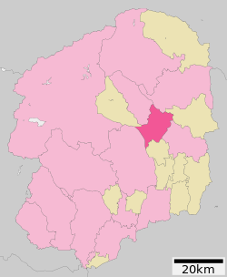
 Location of Sakura in Tochigi Prefecture | |
| Coordinates: 36°41′7″N 139°57′59.1″E / 36.68528°N 139.966417°E | |
| Country | Japan |
| Region | Kantō |
| Prefecture | Tochigi |
| Area | |
| • Total | 125.63 km2 (48.51 sq mi) |
| Population (April 1, 2021) | |
| • Total | 44,712 |
| • Density | 360/km2 (920/sq mi) |
| Time zone | UTC+9 (Japan Standard Time) |
| - Tree | Sakura |
| - Flower | Sakura |
| - Bird | Wagtail |
| Phone number | 028-681-1111 |
| Address | 2771 Ujiie, Sakura-shi, Tochigi-ken 329-1311 |
| Website | Official website |


Sakura (さくら市, Sakura-shi) is a city located in Tochigi Prefecture, Japan. As of 1 April 2021[update], the city had an estimated population of 44,712 in 16,882 households,[1] and a population density of 360 persons per km2. The total area of the city is 125.63 square kilometres (48.51 sq mi).
Geography
[edit]Sakura is located in central-east Tochigi Prefecture, at the far-northern portion of the Kantō plains. the city is approximately 115 kilometers north of the Tokyo metropolis and 15 kilometers north of the prefectural capital of Utsunomiya. It consists mostly of flat land extending to the east of the Kinugawa River, and hilly land to the east of several tributaries of the Naka River.
Surrounding municipalities
[edit]Climate
[edit]Sakura has a Humid continental climate (Köppen Cfa) characterized by warm summers and cold winters with heavy snowfall. The average annual temperature in Sakura is 13.1 °C. The average annual rainfall is 1425 mm with September as the wettest month. The temperatures are highest on average in August, at around 24.9 °C, and lowest in January, at around 1.6 °C.[2]
Demographics
[edit]Per Japanese census data,[3] the population of Sakura has recently plateaued after a long period of growth.
| Year | Pop. | ±% |
|---|---|---|
| 1960 | 33,375 | — |
| 1970 | 32,495 | −2.6% |
| 1980 | 34,820 | +7.2% |
| 1990 | 36,543 | +4.9% |
| 2000 | 40,030 | +9.5% |
| 2010 | 44,774 | +11.9% |
| 2020 | 44,513 | −0.6% |
History
[edit]The town of Kitsuregawa was established on April 1, 1889 with the creation of the modern municipalities system. The city of Sakura was established on March 28, 2005 with the merger of the towns of Kitsuregawa and Ujiie (both from Shioya District).
Government
[edit]Sakura has a mayor-council form of government with a directly elected mayor and a unicameral city assembly of 18 members. Sakura, together with the towns of Shioya and Takanezawa collectively contributes two members to the Tochigi Prefectural Assembly. In terms of national politics, the town is part of Tochigi 2nd district of the lower house of the Diet of Japan.
Economy
[edit]Agriculture, primarily rice cultivation, is a mainstay of the local economy. The city is increasingly a bedroom community for nearby Utsunomiya.
Education
[edit]Sakura has six public primary schools, two public middle schools operated by the city government. The city has one public high school operated by the Tochigi Prefectural Board of Education.
Transportation
[edit]Railway
[edit]![]() JR East – Tōhoku Main Line (Utsunomiya Line)
JR East – Tōhoku Main Line (Utsunomiya Line)
Highway
[edit]Local attractions
[edit]- Kitsuregawa Castle and the Sakura City Museum of Art are located in Sakura.[4]
References
[edit]- ^ "Sakura City official statistics" (in Japanese). Japan.
- ^ Sakura climate data
- ^ Sakura population statistics
- ^ Liedtke, Walter A.; Plomp, Michiel; Rüger, Axel (2001). Vermeer and the Delft School. Metropolitan Museum of Art. p. 610. ISBN 978-0-87099-973-4. Retrieved 17 October 2012.
External links
[edit]![]() Media related to Sakura, Tochigi at Wikimedia Commons
Media related to Sakura, Tochigi at Wikimedia Commons
- Official Website (in Japanese)


